North Carolina Geodetic Survey News Archive
|
FAA issues notice of GPS interference testing
|
| Tuesday, March 24, 2026 |
The Federal Aviation Administration (FAA) has issued the following notice of GPS interference testing that may result in unreliable or unavailable GPS signal:
|
|
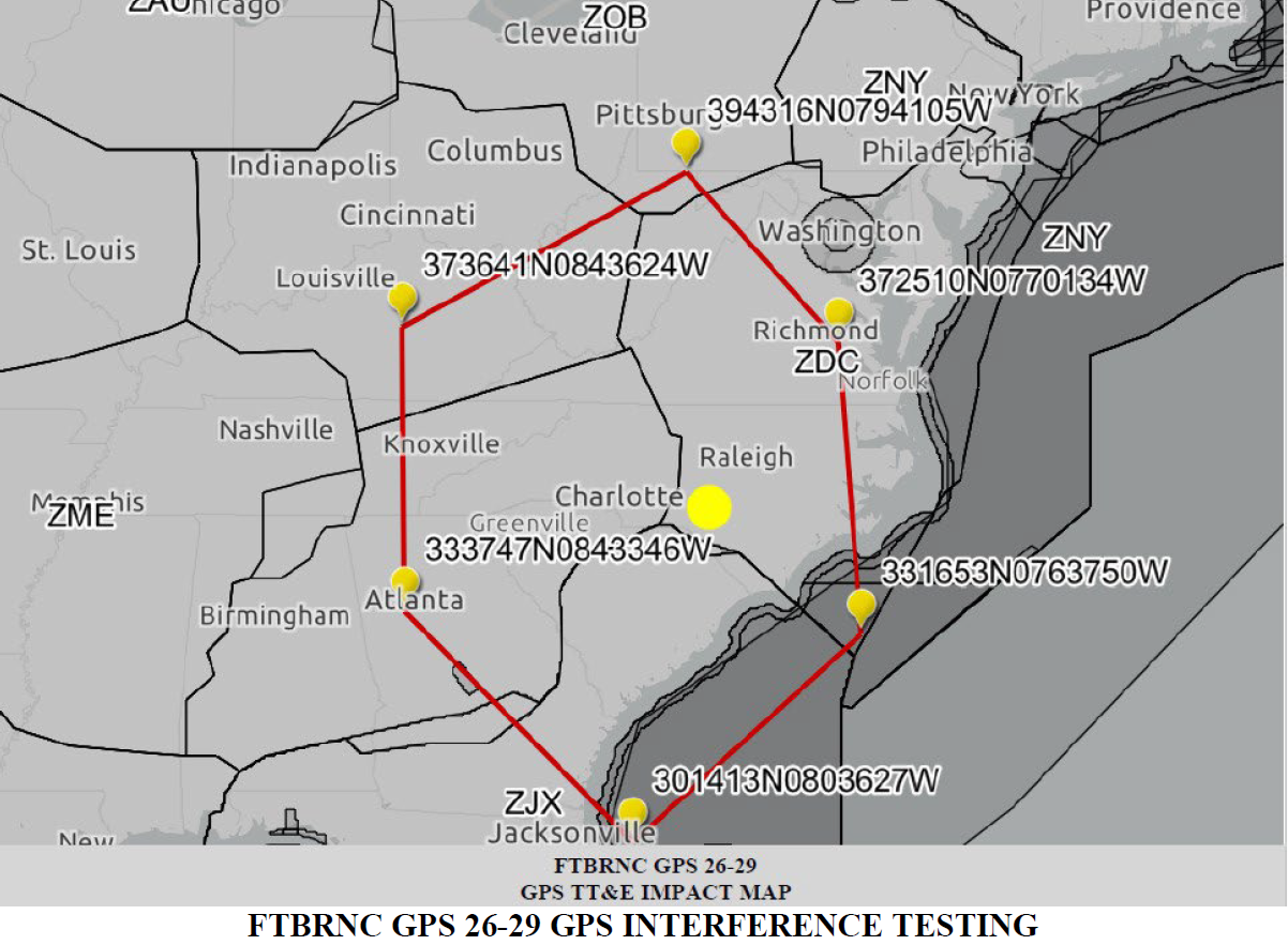
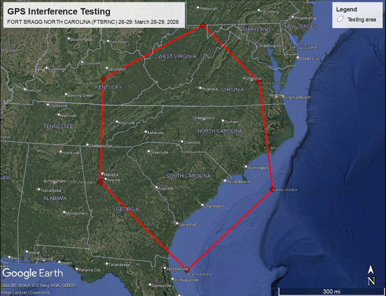
FLIGHT ADVISORY GPS INTERFERENCE TESTING
FORT BRAGG NORTH CAROLINA (FTBRNC) 26-29
26 – 29 March 2026 / Fort Bragg, NC
|
|
Please note that this particular test is not the typical GPS interference test that is centered at a point and impacting an expanding radius with increasing elevation like an upside-down truncated cone. Rather, this test will impact the following area from the surface to UNL (altitudes greater than 99,900 FT):
|
The testing will be conducted each day from 2:30 pm EDT to 10:30 pm EDT.
Note: The notice has the dates from March 26-30, but that is because of using UTC times, such that the evening testing will end each night at 0230Z on the next day. When the times are put in EDT, then the testing ends each night at 10:30 pm EDT.
|
FAA issues notice of GPS interference testing
|
| Wednesday, March 11, 2026 |
The Federal Aviation Administration (FAA) has issued the following notice of GPS interference testing that may result in unreliable or unavailable GPS signal:
|
|
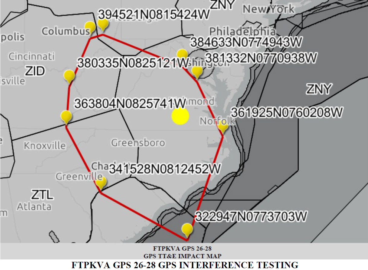
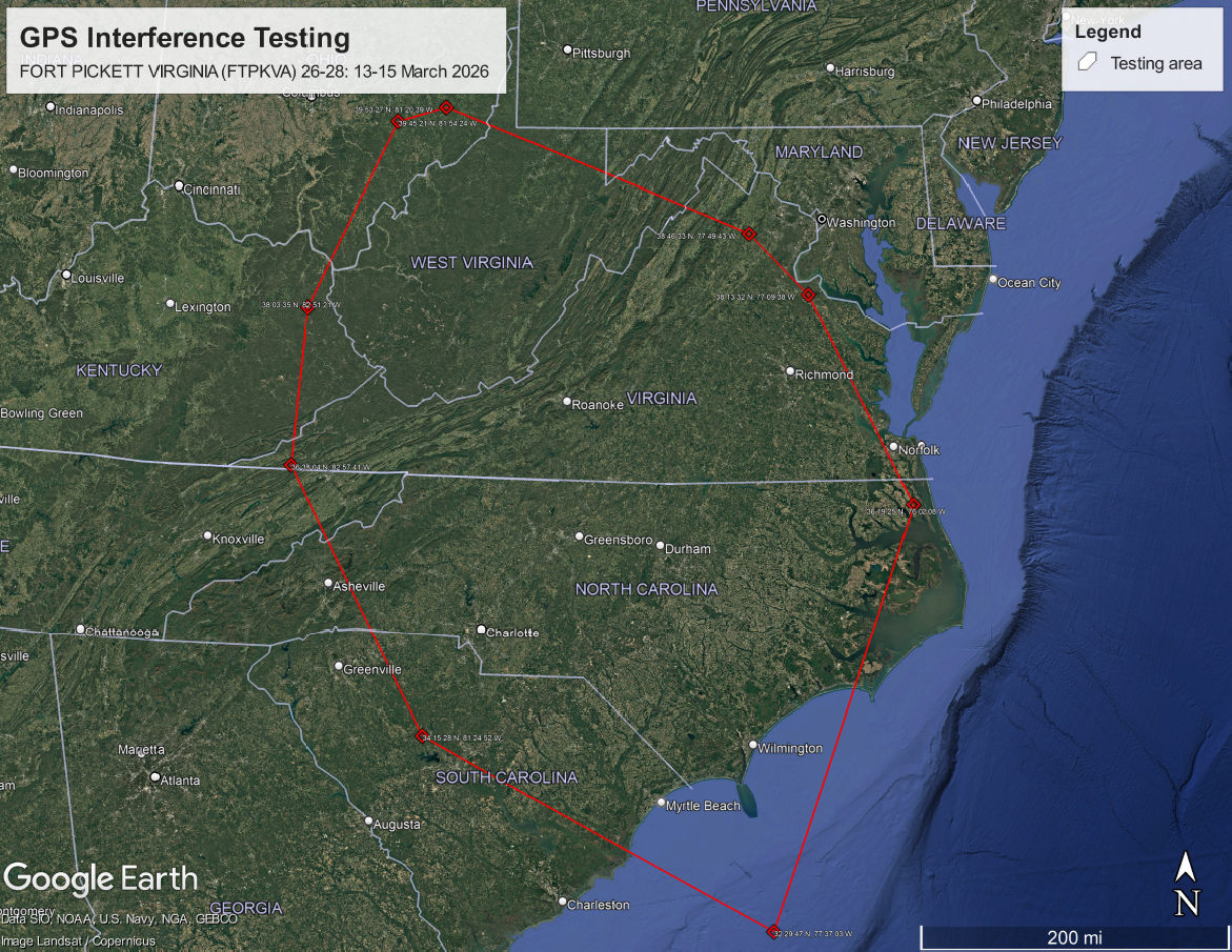
FLIGHT ADVISORY GPS INTERFERENCE TESTING
FORT PICKETT VIRGINIA (FTPKVA) 26-28
13 – 15 March 2026 / Fort Pickett, VA
|
|
Please note that this particular test is not the typical GPS interference test that is centered at a point and impacting an expanding radius with increasing elevation like an upside-down truncated cone. Rather, this test will impact the following area from the surface to UNL (altitudes greater than 99,900 FT):
|
The testing will be conducted each day in two sessions:
- 7:00 am EDT - 12:00 pm EDT
- 2:00 pm EDT - 7:00 pm EDT
|
FAA issues notice of GPS interference testing
|
| Wednesday, March 4, 2026 |
The Federal Aviation Administration (FAA) has issued the following notice of GPS interference testing that may result in unreliable or unavailable GPS signal:
|
|
FLIGHT ADVISORY GPS INTERFERENCE TESTING
VIRGINIA BEACH VIRGINIA (VBBIVA) 26-19 (REVISION 1)
08 – 13 March 2026 / Off-the-Coast, VA
|
|
Please note that this particular test is not the typical GPS interference test that is centered at a point and impacting an expanding radius with increasing elevation like an upside-down truncated cone. Rather, this test will impact the following area from the surface to UNL (altitudes greater than 99,900 FT):

|
The testing will be conducted each night from 11:00 pm EDT to 6:00 am EDT starting the evening of March 8th through the morning of March 13th.
|
FAA issues notice of GPS interference testing
|
| Wednesday, February 4, 2026 |
The Federal Aviation Administration (FAA) has issued the following notice of GPS interference testing that may result in unreliable or unavailable GPS signal:
|
|
FLIGHT ADVISORY GPS INTERFERENCE TESTING
CARRIER STRIKE GROUP FOUR (CSG4) 26-01
07 - 21 February / Off-the-Coast, SC
|
FAA issues notice of GPS interference testing
|
| Wednesday, January 7, 2026 |
The Federal Aviation Administration (FAA) has issued the following notice of GPS interference testing that may result in unreliable or unavailable GPS signal:
|
|
FLIGHT ADVISORY GPS INTERFERENCE TESTING
MARINE CORPS SPECIAL OPERATIONS COMMAND
NORTH CAROLINA (MSOCNC) 26-01
07- 14 January / Camp Lejeune, NC
|
FAA issues notice of GPS interference testing
|
| Friday, December 5, 2025 |
The Federal Aviation Administration (FAA) has issued the following notice of GPS interference testing that may result in unreliable or unavailable GPS signal:
|
|
FLIGHT ADVISORY GPS INTERFERENCE TESTING
CARRIER STRIKE GROUP FOUR (CSG4) 25-07
10 December / Off-the-Coast, SC
|
FAA issues notice of GPS interference testing
|
| Wednesday, November 26, 2025 |
The Federal Aviation Administration (FAA) has issued the following notice of GPS interference testing that may result in unreliable or unavailable GPS signal:
|
|
FLIGHT ADVISORY GPS INTERFERENCE TESTING
MARINE CORPS SPECIAL OPERATIONS COMMAND
NORTH CAROLINA (MSOCNC) 25-05
01 – 12 December / Jacksonville, NC
|
NOAA issues a significant space weather forecast
|
| Wednesday, November 12, 2025 |
The National Oceanic and Atmospheric Administration (NOAA) has issued a space weather forecast for a severe (scale G4) geomagnetic storm that could impact GPS navigation on the afternoon of Wednesday, November 12th, 1:00 pm EST to 4:00 pm EST (18:00 UTC to 21:00 UTC).
|
|
Potential impacts to GPS navigation:
- Strong (scale G3): Intermittent satellite navigation (GPS) problems, including loss-of-lock and increased range error may occur.
- Severe (scale G4): Satellite navigation (GPS) degraded or inoperable for hours.
|
|
NOAA Space Weather info:
|
FAA issues notice of GPS interference testing
|
| Tuesday, October 28, 2025 |
The Federal Aviation Administration (FAA) has issued the following notice of GPS interference testing that may result in unreliable or unavailable GPS signal:
|
|
FLIGHT ADVISORY GPS INTERFERENCE TESTING
CARRIER STRIKE GROUP FOUR (CSG4) 25-06 (REVISION 1)
31 October - 09 November / Off-the-Coast, SC
|
FAA issues notice of GPS interference testing
|
| Friday, October 3, 2025 |
The Federal Aviation Administration (FAA) has issued the following notice of GPS interference testing that may result in unreliable or unavailable GPS signal:
|
|
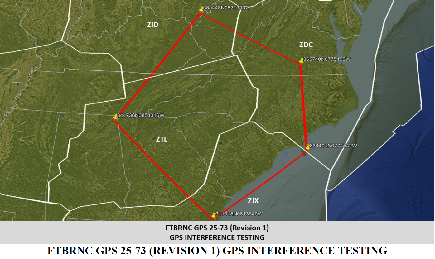
FLIGHT ADVISORY GPS INTERFERENCE TESTING
FORT BRAGG NORTH CAROLINA (FTBRNC) 25-73 (REVISION 1)
04 - 07 October 2025 / Fort Bragg, NC
|
|
Please note that this particular test is not the typical GPS interference test that is centered at a point and impacting an expanding radius with increasing elevation like an upside-down truncated cone. Rather, this test will impact the following area from the surface to UNL (altitudes greater than 99,900 FT):
|
FAA issues notice of GPS interference testing
|
| Friday, October 3, 2025 |
The Federal Aviation Administration (FAA) has issued the following notice of GPS interference testing that may result in unreliable or unavailable GPS signal:
|
|
FLIGHT ADVISORY GPS INTERFERENCE TESTING
MARINE CORPS INSTALLATIONS EAST NORTH CAROLINA (MCIENC) 25-01
04 October / Atlantic, NC
|
FAA issues notice of GPS interference testing
|
| Friday, September 12, 2025 |
The Federal Aviation Administration (FAA) has issued the following notice of GPS interference testing that may result in unreliable or unavailable GPS signal:
|
|
FLIGHT ADVISORY GPS INTERFERENCE TESTING
FORT PICKETT VIRGINIA (FTPKVA) 25-78
16 - 24 September / Fort Pickett, VA
|
FAA issues notice of GPS interference testing
|
| Friday, July 18, 2025 |
The Federal Aviation Administration (FAA) has issued the following notice of GPS interference testing that may result in unreliable or unavailable GPS signal:
|
|
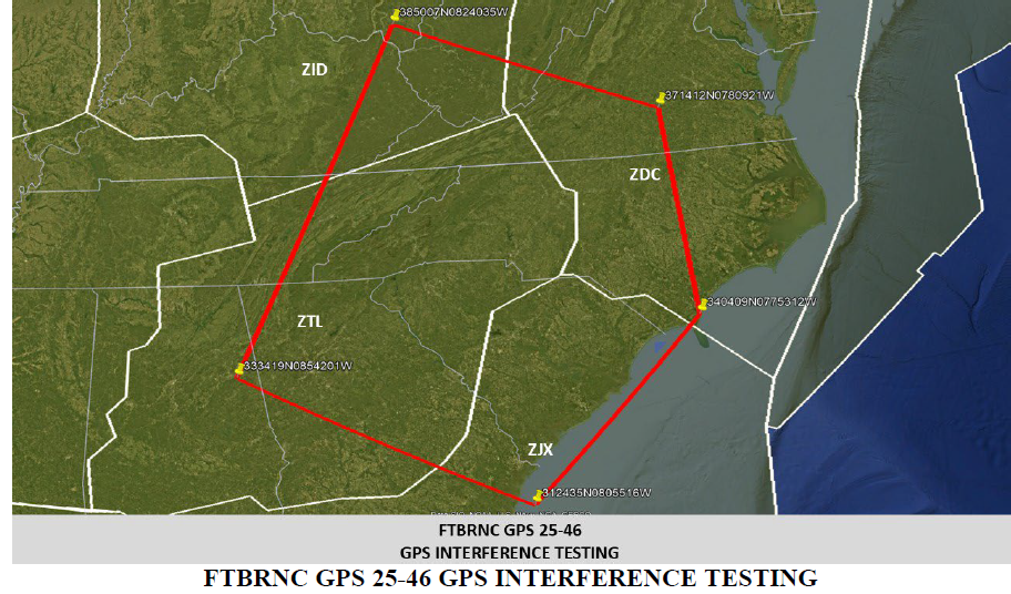
FLIGHT ADVISORY GPS INTERFERENCE TESTING
FORT BRAGG NORTH CAROLINA (FTBRNC) 25-46
23 - 25 July 2025 / Fort Bragg, NC
|
|
Please note that this particular test is not the typical GPS interference test that is centered at a point and impacting an expanding radius with increasing elevation like an upside-down truncated cone. Rather, this test will impact the following area from the surface to UNL (altitudes greater than 99,900 FT):
|
FAA issues notice of GPS interference testing
|
| Tuesday, June 24, 2025 |
The Federal Aviation Administration (FAA) has issued the following notice of GPS interference testing that may result in unreliable or unavailable GPS signal:
|
|
FLIGHT ADVISORY GPS INTERFERENCE TESTING
CARRIER STRIKE GROUP FOUR (CSG4) 25-05
26 - 29 June / Off-The-Coast, SC
|
FAA issues notice of GPS interference testing
|
| Wednesday, June 18, 2025 |
The Federal Aviation Administration (FAA) has issued the following notice of GPS interference testing that may result in unreliable or unavailable GPS signal:
|
|
FLIGHT ADVISORY GPS INTERFERENCE TESTING
MARINE CORPS SPECIAL OPERATIONS COMMAND NORTH CAROLINA (MSOCNC) 25-04
19 June 2025 / Bogue Field, NC
|
FAA issues notice of GPS interference testing
|
| Thursday, May 29, 2025 |
The Federal Aviation Administration (FAA) has issued the following notice of GPS interference testing that may result in unreliable or unavailable GPS signal:
|
|
FLIGHT ADVISORY GPS INTERFERENCE TESTING
MARINE CORPS SPECIAL OPERATIONS COMMAND NORTH CAROLINA (MSOCNC) 25-01 (REVISION 1)
02 – 20 June / Holly Ridge, NC
|
FAA issues notice of GPS interference testing
|
| Thursday, May 15, 2025 |
The Federal Aviation Administration (FAA) has issued the following notice of GPS interference testing that may result in unreliable or unavailable GPS signal:
|
|
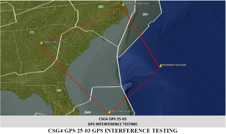
FLIGHT ADVISORY GPS INTERFERENCE TESTING
CARRIER STRIKE GROUP FOUR (CSG4) 25-03
20 May 2025 / Off-the-Coast, NC
|
|
Please note that this particular test is not the typical GPS interference test that is centered at a point and impacting an expanding radius with increasing elevation like an upside-down truncated cone. Rather, this test will impact the following area from the surface to UNL (altitudes greater than 99,900 FT):
|
FAA issues notice of GPS interference testing
|
| Wednesday, April 30, 2025 |
The Federal Aviation Administration (FAA) has issued the following notice of GPS interference testing that may result in unreliable or unavailable GPS signal:
|
|
FLIGHT ADVISORY GPS INTERFERENCE TESTING
MARINE CORPS SPECIAL OPERATIONS COMMAND NORTH CAROLINA (MSOCNC) 25-03 (REVISION 1)
05 – 09 May / Holly Ridge, NC
|
NOAA issues space weather alert
|
| Wednesday, April 16, 2025 |
The National Oceanic and Atmospheric Administration (NOAA) issued the following space weather alert of a geomagnetic storm, which has since passed, that may have resulted in GPS navigation and positioning problems of loss-of-lock and increased range error:
|
|
ALERT: Geomagnetic K-index of 7 (ALTK07)
- Serial Number: 181
- Issue Time: 2025 Apr 16 1424 UTC [10:24 EDT]
- Threshold Reached: 2025 Apr 16 1418 UTC [10:18 am EDT]
- Synoptic Period: 1200-1500 UTC [8:00 am EDT - 11:00 am EDT]
- NOAA Scale: G3 - Strong
|
|
NOAA Space Weather info:
|
|
Potential impacts to GPS: Intermittent satellite navigation (GPS) problems, including loss-of-lock and increased range error may have occurred.
|
FAA issues notice of GPS interference testing
|
| Thursday, April 03, 2025 |
The Federal Aviation Administration (FAA) has issued the following notice of GPS interference testing that may result in unreliable or unavailable GPS signal:
|
|
FLIGHT ADVISORY GPS INTERFERENCE TESTING
MARINE CORPS SPECIAL OPERATIONS COMMAND (MSOCNC) 25-02
05 – 15 April / Sneads Ferry, NC
|
FAA issues notice of GPS interference testing
|
| Wednesday, March 19, 2025 |
The Federal Aviation Administration (FAA) has issued the following notice of GPS interference testing that may result in unreliable or unavailable GPS signal:
|
|
FLIGHT ADVISORY GPS INTERFERENCE TESTING
CARRIER STRIKE GROUP FOUR (CSG4) 25-02
23 March - 02 April / Off-The-Coast, SC
|
FAA issues notice of GPS interference testing
|
| Thursday, February 27, 2025 |
The Federal Aviation Administration (FAA) has issued the following notice of GPS interference testing that may result in unreliable or unavailable GPS signal:
|
|
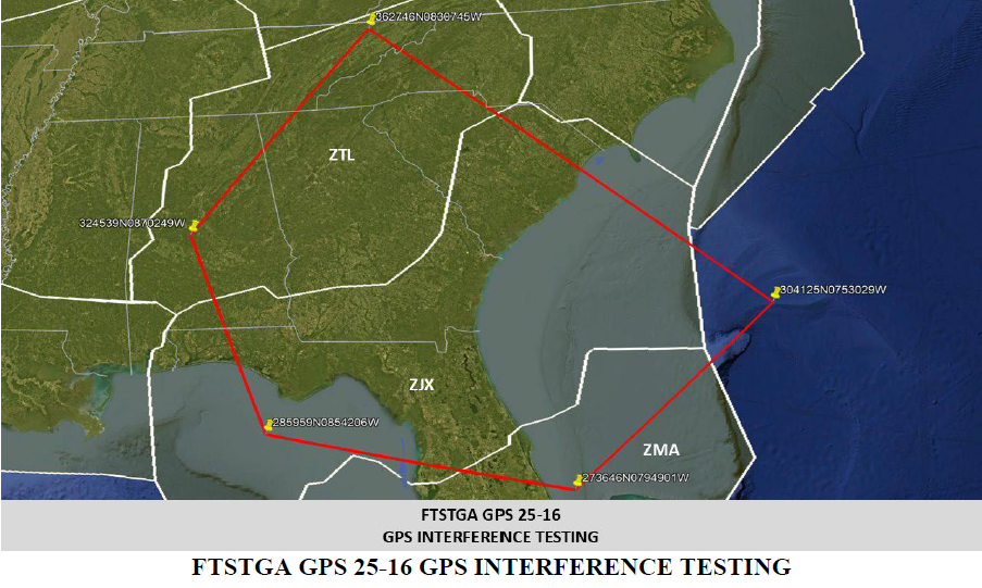
FLIGHT ADVISORY GPS INTERFERENCE TESTING
FORT STEWART GEORGIA (FTSTGA) 25-16
04 – 12 March / Fort Stewart, GA
|
|
Please note that this particular test is not the typical GPS interference test that is centered at a point and impacting an expanding radius with increasing elevation like an upside-down truncated cone. Rather, this test will impact the following area from the surface to UNL (altitudes greater than 99,900 FT):
|
NC Geodetic Survey Position Openings
|
| Wednesday, February 12, 2025 |
The NC Geodetic Survey announces three positions open for applicants. The positions are listed by title below, with a link to a detailed posting and application for each.
Note that the following positions have closed but the links will be left up for archive purposes.
|
|
Survey Crew Technician: https://www.governmentjobs.com/careers/northcarolina/jobs/4726044/survey-crew-technician
Survey Crew Technician: https://www.governmentjobs.com/careers/northcarolina/jobs/4736724/survey-crew-technician
CORS/RTN Manager: https://www.governmentjobs.com/careers/northcarolina/jobs/4828841/cors-rtn-manager
|
FAA issues notice of GPS interference testing
|
| Wednesday, February 5, 2025 |
The Federal Aviation Administration (FAA) has issued the following notice of GPS interference testing that may result in unreliable or unavailable GPS signal:
|
|
FLIGHT ADVISORY GPS INTERFERENCE TESTING
FORT LIBERTY NORTH CAROLINA (FTLBNC) 25-26
09 - 12 February / Fort Liberty, NC
|
|
Please note that this particular test is not the typical GPS interference test that is centered at a point and impacting an expanding radius with increasing elevation like an upside-down truncated cone. Rather, this test will impact the following area from the surface to UNL (altitudes greater than 99,900 FT):
|
FAA issues notice of GPS interference testing
|
| Thursday, January 30, 2025 |
The Federal Aviation Administration (FAA) has issued the following notice of GPS interference testing that may result in unreliable or unavailable GPS signal:
|
|
FLIGHT ADVISORY GPS INTERFERENCE TESTING
FORT LIBERTY NORTH CAROLINA (FTLBNC) 25-14 (REVISION 1)
30 January - 04 February / Fort Liberty, NC
|
|
Please note that this particular test is not the typical GPS interference test that is centered at a point and impacting an expanding radius with increasing elevation like an upside-down truncated cone. Rather, this test will impact the following area from the surface to UNL (altitudes greater than 99,900 FT MSL):
|
FAA issues notice of GPS interference testing
|
| Thursday, January 30, 2025 |
The Federal Aviation Administration (FAA) has issued the following notice of GPS interference testing that may result in unreliable or unavailable GPS signal:
|
|
FLIGHT ADVISORY GPS INTERFERENCE TESTING
CARRIER STRIKE GROUP FOUR (CSG4) 25-01
30 January - 01 February / Off-The-Coast, SC
|
Intermittent issues with NCGS Geodetic Control Database
|
|
Friday, August 21, 2020
|
Users of the NCGS Geodetic Control Database (https://ncgs.nc.gov/geodeticmonuments) may notice some intermittent outages. NCGS is aware of the issue and is working to resolve it as quickly as possible.
|
|
In the meantime, users may want to try accessing the database via a different browser, and/or users may try a hard refresh to force the browser to fully reload the database page. On most browsers a hard refresh can be accomplished by pressing CTRL+F5, but users should consult their browser help resources for exact instructions. Neither of these solutions are a guaranteed fix, but they have resolved the issue in some cases.
|
Galileo & BeiDou satellite data now included in NC RTN solution
|
|
Tuesday, June 2, 2020
|
As of today, June 1, 2020, the VRS_CMRx and VRS_RTCM32 mountpoints have been configured to include the Galileo and BeiDou satellite data into the correction solution to NC RTN users. CMRx and RTCM 3.2 are the only versions of the output formats the NC RTN has available for the mountpoints that support the Galileo and BeiDou satellite data. The other mountpoints (VRS_CMRp, VRS_RTCM23, VRS_RTCM3) will still include only the GPS and GLONASS satellite data in the solution. Although the VRS_CMRx and VRS_RTCM32 mountpoints are now configured to include the Galileo and BeiDou satellite data, users may not receive any BeiDou satellite correction data because the NC RTN application can’t process the data from the latest BeiDou satellites (BeiDou-3) yet.
|
Please update your NCGS website bookmark
|
|
Tuesday, November 18, 2019
|
The NC Geodetic Survey website has undergone some recent back-end changes to enhance security and functionality. If you have not already done so, please update your bookmark for the NCGS page to the URL below.
|
|
GPS Week Number Rollover
|
| Thursday, March 28, 2019 |
|
The GPS Week Number will reset to zero at 23:59:42 UTC on April 6, 2019. Please visit the link below for more information. The GPS Week Number rollover information is at the top right of the page.
|
High Water Mark Location Collection Tool
|
| Wednesday, September 12, 2018 |
|
The high water mark collection tool can be accessed using the link below:
|
NCGS selects three firms for the aerial imagery quality control (QC) project
|
| Thursday, May 31, 2018 |
|
The North Carolina Geodetic Survey selected the following private surveying firms for the aerial imagery quality control (QC) project (RFQ #295-01-2018):
• CESI (Concord Engineering & Surveying, Inc.)
• Merrick & Company
• Vaughn & Melton Consulting Engineers, Inc.
|
2022 Datum Information Available
|
| Monday, April 30, 2018 |
|
A new category has been added to the library specifically for information related to the 2022 datum change. In the document library (available at the link below), choose the "2022 Reference Frame" category from the dropdown menu. This information was edited on 13-April-2026 to correct a broken link.
|
Request for Qualifications (RFQ) issued for aerial imagery quality control (QC) project
|
| Tuesday, January 23, 2018 |
|
The North Carolina Geodetic Survey (NCGS) intends to award multiple Qualifications-Based Selection (QBS) contracts to private surveying firms for the purpose of performing aerial imagery quality control (QC) surveys utilizing Global Navigation Satellite System (GNSS) and traditional survey methods to support the Statewide Digital Orthoimagery Project.
The purpose of the orthoimagery project, which is funded by the North Carolina 911 Board (http://www.nc911.nc.gov/), is to collect seamless aerial imagery for use by local 911 agencies; local, state and federal agencies; and the public.
The work for this Request for Qualifications (RFQ) would consist of performing horizontal and vertical quality control (QC) survey projects. For more information, please visit the following URL:
|
Informative videos available
|
| Wednesday, November 8, 2017 |
|
A collection of short, informative videos about various topics have been made available. The videos can be accessed by clicking the links below:
Continuously Operating Reference Station (CORS) videos
|
Solar storm alert
|
| Wednesday, September 6, 2017 |
Expected solar storm serves as a reminder to always check the space weather forecast before doing any GNSS surveying, precision agriculture, or GNSS-guided earthmoving work
The sun had a coronal mass ejection (CME) on September 4 that is expected to produce one or more geomagnetic storms on September 6 and 7. The NOAA Space Weather Prediction Center (SWPC) has issued a G3 (strong) geomagnetic storm watch for this event.
How does space weather affect GNSS work? NASA provides the following response:
In calm conditions, single frequency GPS systems can provide position information with an accuracy of a meter or less. During a severe space weather storm, these errors can increase to tens of meters or more. Dual frequency GPS systems can provide position information accurate to a few centimeters. In this case the two different GPS signals are used to better characterize the ionosphere and remove its impact on the position calculation. But when the ionosphere becomes highly disturbed, the GPS receiver cannot lock on the satellite signal and position information becomes inaccurate.
Geomagnetic storms create large disturbances in the ionosphere. The currents and energy introduced by a geomagnetic storm enhance the ionosphere and increase the total height-integrated number of ionospheric electrons, or the Total Electron Count (TEC). GPS systems cannot correctly model this dynamic enhancement and errors are introduced into the position calculations. This usually occurs at high latitudes, though major storms can produce large TEC enhancements at mid-latitudes as well.
Therefore, please always check the following SWPC webpages before doing any GNSS work:
|
Update regarding NGS web services outage
|
| Monday, September 12, 2016 |
|
The NGS HQ building experienced a fire event Friday Sept 9. All servers were shut down and limited user functionality such as CORS data, datasheets and geodetic utilities were switched to the backup systems in Boulder, CO. NGS is working on restoring full service sometime Monday Sept. 12.
|
Informative videos available
|
| Friday, September 9, 2016 |
A pair of short, informative videos about EDMI baselines are now available. The videos can be accessed by clicking the links below:
The link below allows the user to download the NCDOT EDMI check program as a zipped file.
|
Meeting of the North Carolina Boundary Commission
|
| Monday, July 25, 2016 |
|
Notice is hereby given of a meeting of the North Carolina Boundary Commission
|
NCGS selects three firms for the aerial imagery quality control (QC) project
|
| Friday, March 11, 2016 |
|
The North Carolina Geodetic Survey selected the following private surveying firms for the aerial imagery quality control (QC) project (RFQ #295-01-2016):
• CESI
• Stantec Consulting Services Inc.
• Vaughn & Melton Consulting Engineers, Inc.
|
Request for Qualifications (RFQ) issued for aerial imagery quality control (QC) project
|
| Thursday, January 28, 2016 |
The North Carolina Geodetic Survey (NCGS) intends to award multiple Qualifications-Based Selection (QBS) contracts to private surveying firms for the purpose of performing aerial imagery quality control (QC) surveys utilizing Global Navigation Satellite System (GNSS) and traditional survey methods to support the Statewide Digital Orthoimagery Project.
The purpose of the orthoimagery project, which is funded by the North Carolina 911 Board (http://www.nc911.nc.gov/), is to collect seamless aerial imagery for use by local 911 agencies; local, state and federal agencies; and the public.
The work for this Request for Qualifications (RFQ) would consist of performing horizontal and vertical quality control (QC) survey projects. For more information, please visit the following URL:
https://www.ips.state.nc.us/ips/AGENCY/PDF/11154000.pdf
|
Web Link to North Carolina's Spatial Data Download
|
| Thursday, January 28, 2016 |
Users wishing to download NC spatial data may do so at the following link (link corrected 13-April-2026):
https://sdd.nc.gov/
|
Informative videos available
|
| Thursday, July 30, 2015 |
A series of short video tutorials are now available to help navigate the most-recently developed NC Geodetic Database. The videos can be accessed by clicking the link below:
|
Solar storm alert
|
| Monday, June 1, 2015 |
Expected solar storm serves as a reminder to always check the space weather forecast before doing any GNSS surveying, precision agriculture, or GNSS-guided earthmoving work
The sun had a coronal mass ejection (CME) on June 18, 19, and 21 that we are experiencing as a series of geomagnetic storms. The NOAA Space Weather Prediction Center (SWPC) announced on Monday, June 22, that "the geomagnetic storm began as forecasted and quickly ramped up to severe (G4) levels."
On June 23, SWPC predicted the following over the June 23, 24, & 25 period:
The geomagnetic field is expected to remain agitated with G1-G2 (Minor - Moderate) possible early on day one (23 Jun) in continued response to the 21 Jun CME. Conditions are expected to continue to gradually taper off below G1 (Minor) over the next 12-18 hours back to quiet to active conditions. The 21 Jun CME is expected to arrive late on day two (24 Jun) to early on day three (25 Jun). The CME will likely enhance geomagnetic conditions to G1-G2 (Minor-Moderate) levels with the possibility for stronger conditions on day three (25 Jun).
On June 24, SWPC predicted the following over the June 24, 25, & 26 period:
G1 (Minor) geomagnetic storms are expected with waning effects from past CME. With the onset of the new CME, storming conditions up to G3 (Strong) are likely.
It is important to note that the SWPC reported the following in its June 23rd 3-Day Forecast, “No radio blackouts were observed over the past 24 hours.” Furthermore, SWPC predicted a 75% chance of minor-moderate (R1-R2) radio blackout levels for June 24, 25, and 26 and a 20% chance of a strong (R3 or greater) radio blackout over the 3-day period. SWPC explained, “R1-R2 (Minor-Moderate) or greater radio blackouts are expected, with a slight chance for R3 (Strong) radio blackouts on days one through three (24-26 Jun) due to flare potential from region 2371.”
How does space weather affect GNSS work? NASA provides the following response:
In calm conditions, single frequency GPS systems can provide position information with an accuracy of a meter or less. During a severe space weather storm, these errors can increase to tens of meters or more. Dual frequency GPS systems can provide position information accurate to a few centimeters. In this case the two different GPS signals are used to better characterize the ionosphere and remove its impact on the position calculation. But when the ionosphere becomes highly disturbed, the GPS receiver cannot lock on the satellite signal and position information becomes inaccurate.
Geomagnetic storms create large disturbances in the ionosphere. The currents and energy introduced by a geomagnetic storm enhance the ionosphere and increase the total height-integrated number of ionospheric electrons, or the Total Electron Count (TEC). GPS systems cannot correctly model this dynamic enhancement and errors are introduced into the position calculations. This usually occurs at high latitudes, though major storms can produce large TEC enhancements at mid-latitudes as well.
Therefore, it is advisable to not do any GNSS work over the next three days, if possible. As for work that was conducted during the geomagnetic storm’s most severe periods (2:00 pm – 5:00 pm EDT on June 22 and 11 pm EDT on June 22 to 2:00 am EDT on June 23) that work may need to be repeated.
Therefore, please always check the following SWPC webpages before doing any GNSS work:
|
NGS Releases New Beta Version of Transformational Tool
|
| Monday, June 1, 2015 |
The National Geodetic Survey (NGS) is pleased to announce the Beta release of a new and improved transformation tool in the NGS geodetic toolkit. This redesigned version supports the transformation between geodetic coordinates and State Plane Coordinates (SPC), Universal Transverse Mercator (UTM) coordinates, Cartesian coordinates (XYZ), and U.S. National Grid (USNG) coordinates as a one-stop solution. It features transformation of single or multiple points, Web services, and software downloads. NGS encourages users to try the Beta Version and provide feedback to Krishna.Tadepalli@noaa.gov so the final version may be improved prior to release as on official NGS product.
The update was in the development stage for several months, and it provides surveyors and geodesists with a more efficient and streamlined way of accessing frequently used NGS tools in the geodetic toolkit. The new interface allows one-page easy access to transformations that were previously available only on separate pages.
The Beta version is accessible at: http://beta.ngs.noaa.gov/gtkweb
|
GEOID12B Released
|
| Thursday, April 23, 2015 |
From NGS
"When using the geoid models, please be advised that GEOID12B should supersede previous models GEOID12 and GEOID12A. GEOID12B is identical to GEOID12A everywhere, except in Puerto Rico and Virgin island region. For more detail, please read Technical details."
Visit the GEOID12B page at NGS: http://www.ngs.noaa.gov/GEOID/GEOID12B/
|
NC-SC Boundary Commision Meeting
|
| Monday, March 23, 2015 |
MEDIA ADVISORY
WHAT: The joint boundary commission is a cooperative effort between North Carolina and South Carolina to reestablish our original common boundary, which is the official boundary, in order to minimize jurisdictional conflicts caused by the uncertain location of this boundary. The purpose of this meeting is to discuss the proposed legislation to be filed in each state to reduce impacts on those residents and property owners affected by the clarification of the boundary.
WHEN: Friday, March 27, 2015 10 a.m. to 2 p.m.
WHERE: Baxter Hood Center, Bowater Room
York Technical College
452 South Anderson Road
Rock Hill, SC 29730
AGENDA:
10:00 Welcome, introductions, and objectives for the day
Alan-Jon Zupan, meeting moderator and co-chair of the NC-SC Joint Boundary Commission
10:10 Review and discussion of the proposed legislation to minimize impacts on affected residents and property owners
11:30 Public Comments
12:00 Lunch
12:45 Discussion on the proposed legislation (continued)
|
GPS on Bench Marks Webinar
|
| Tuesday, March 03, 2015 |
NOAA’s National Geodetic Survey encourages anyone with survey-grade Global Positioning System (GPS) receivers or GPS-enabled phones and hand held devices to help collect GPS on Bench Marks. This webinar will provide guidance to collect GPS observations at any time, including during National Surveyors Week (March 15–21, 2015). Joining the 2015 effort will help raise awareness about professional surveying while improving the National Spatial Reference System (NSRS).
To register and for more information on the webinar (March 5th, 3pm et), visit: http://www.ngs.noaa.gov/corbin/class_description/GPS_on_benchmarks.shtml.
For more information on GPS on Bench Marks, visit: http://www.ngs.noaa.gov/web/surveys/GPSonBM/.
|